WeatherFlow
  • Weather Networks
    • Why Choose WeatherFlow ?
    • WeatherFlow Coastal Mesonet
    • Hurricane Network
    • Wind Energy Mesonet
  • Data and Applications
    • WeatherFlow Weather Engine
    • Communications and Data Delivery
    • Historical Wind Data
    • DataScope
  • Weather
    Modeling
    • WeatherFlow RAMS (WRAMS)
    • Other Weather Models
    • Modeling Initiatives
    • Oceanographic Models
  • Services
    • Wind-Based Financial Indices
    • Professional Services
    • Coastal Forecasting
    • Research
  • Wind Energy
    • Resource Assessment
    • Microscale Forecasting
    • WRAMS Mesoscale Modeling
    • Wind Energy Mesonet
    • SODAR and LIDAR
  • Consumer Products
    • WindAlert
    • SailFlow
    • iWindsurf
    • iKitesurf
    • Fishweather
  • About Us
    • Clients and Partners
    • Careers
    • Contact Us
  • News
Weather-Flow

September 2011

Archives

  • 2013
    • May
    • April
    • February
    • January
  • 2012
    • December
    • November
    • October
    • September
  • 2011
    • December
    • November
    • October
    • September
    • August
    • January
  • 2010
    • December
    • November
    • October
  • 2009
    • December
    • June
    • April
    • March
  • 2008
    • December
    • November
    • April
    • January
  • 2007
    • April
  • Irene-map_-crop

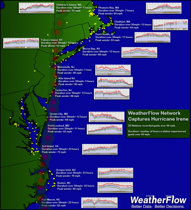
    WeatherFlow Network Captures Hurricane Irene Footprint

    Sep 28

    September 28, 2011. New Smyrna Beach, Florida.
    Hurricane Irene registered tropical storm force winds over a greater geographic area than any storm in the last 20 years according to Wea Read more

    • About Us
    • Clients and Partners
    • Careers
    • Contact Us
© 2013 WeatherFlow